Opening India’s Northeast to the Bay of Bengal
This special report explores how the inland waterways of the northeast—linking ports along the Bay of Bengal to the hinterland—can be utilised to offer these landlocked states the means to benefit from sea trade and the growing opportunities in the Indo-Pacific region.
Introduction
- India’s northeast region (Arunachal Pradesh, Assam, Manipur, Meghalaya, Mizoram, Nagaland, Tripura, and Sikkim) has for long been underdeveloped.
- The region’s strategic potential remains untapped owing to various reasons, primary of which are cross-border security considerations and internal instability.
This special report explores how the inland waterways of the northeast—linking ports along the Bay of Bengal to the hinterland—can be utilised to offer these landlocked states the means to benefit from sea trade and the growing opportunities in the Indo-Pacific region.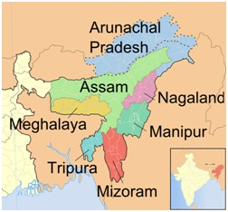
Why India’s NER assumes significance?
- Sharing international borders: The eight states of India’s North Eastern Region (NER) occupy a mere 8 percent of the country’s geographic area. Yet they are strategically important, as between them they share 5,300 km of international borders with the neighbouring countries of Nepal, Bhutan, China, Myanmar, and Bangladesh.
- Gateway to Southeast Asia: Given ASEAN’s significance, the NER becomes important for India’s foreign policy manoeuvres as the only land ‘bridge’ between India and Southeast Asia.
- In recent times, New Delhi has prioritised improving trade and connectivity in the northeast, through a number of multimodal projects, linking the states themselves more closely while connecting them with the rest of India and the ASEAN nations.
What challenges are faced by the region?
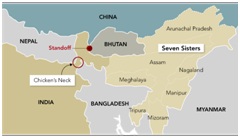
- Lack of connectivity: The NER is at a logistical disadvantage as seven of the eight states are connected to the rest of India through only a narrow strip of land known as the Siliguri (or ‘chicken’s neck’) corridor.
- The total road surface in the region is 33.7 percent, less than half the national average of 69 percent.
- Recurring insurgencies: Troubled, too, by recurring insurgencies, the states suffer poor connectivity.
- Underdevelopment: This has had an impact on the region, causing persistent underdevelopment and “alienation” from the Indian mainland.
- Around 28.5 percent of the NER’s population live below the poverty line—a proportion that is significantly higher than the all-India figure of 21.9 percent.
- Toll on environment:Road and railway projects are costly and carry environmental impacts, too.
- Lack of investment: Despite its resources, the NER has rarely been perceived as a natural destination for investment due to the region’s thin population, difficult terrain, fragile ecology and, until recently, volatile political environment.
- Cross-border conflicts: The NER continues to suffer security concerns from the cross-border conflicts and other illegal activities in the region.
- China: China plays a pivotal role in the border dynamics of this region.
|
Intra-region conflicts Intra-region conflict is an another major challenge for the region
|
What measures are required?
- Sub-regional cooperation: The communities of the northeast are of the view that renewing old bonds of trade and connectivity with India’s neighbouring countries, can help them achieve prosperity.
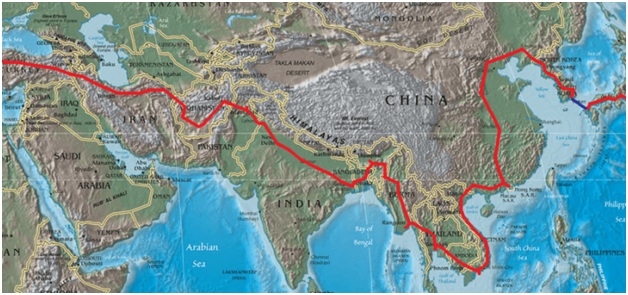
- Historically, India’s northeast had been the south-western track of the ancient Silk Route through which trade was conducted between India, south-west China, Tibet, Bhutan, and Burma (present-day Myanmar).
- Focus on development of waterways: Developing waterways that have links with seaports will provide the northeast the benefit of maritime trade, and improve its connectivity with the rest of India, Southeast Asia, and the wider Indo-Pacific.
- Multi-modal connectivity: Establishing multi-modal connectivity in the north eastern region, with an emphasis on improved trade relations with emerging economies like Myanmar and Bangladesh, will bolster the economic growth of the region.
- Focus on promotion of peace and stability: Empowering local administrations, alongside enhancing regional markets, can promote peace and stability by encouraging collaboration and cooperation with trans-border ethnic groups.
- Effective policy formulation: The government should formulate policies focused on:
- Strengthening infrastructure linkages
- Facilitating trade, investment and tourism
- Developing human resources
- Protecting the environment and promoting the sustainable use of shared natural resources in India’s Northeast
How India is reaching towards its eastern neighbourhood?
- SAGAR: At the Shangri La Dialogue of 2018, Indian Prime Minister Narendra Modi eulogised the vision of Security and Growth for All in the Region (SAGAR) by connecting India’s east and northeast with the country’s eastern neighbours via the Act East Policy.
- Protocol for Inland Water Trade & Transit (PIWTT): India and Bangladesh reached another milestone in 2020, following the operationalization of the Daukandi (Bangladesh) – Sonamura (Tripura) Inland Waterway Protocol route, adding a new feather in the field of cross-border connectivity initiatives.
- The Protocol for Inland Water Trade & Transit (PIWTT) was signed between India and Bangladesh in 1972 to provide inland waterways connectivity between the two countries, particularly with the North Eastern Region of India and also to enhance bilateral trade.
Why ‘groupings’ assumes significance in India’s Act East Policy?
ASEAN
- The countries of Southeast Asia, under the rubric of the Association of South East Asian Nations (ASEAN), occupy a central position in India’s Act East Policy, as India seeks opportunities for collaborative growth amidst China’s assertive rise in the Indian Ocean region.
- Multiple benefits: The ASEAN countries are suited for such engagements with India:
- there are no significant political disputes
- the economies are on a growth trajectory
- there is also shared cultural heritage
- Strategic location: Further, as the Act East Policy gradually morphs into ‘Act Indo-Pacific’, with India’s expanding horizon for convergence and collaboration, the ASEAN countries – located at the junction of the Indian and Pacific Oceans – retain their centrality in India’s vision of the Indo-Pacific.
BIMSTEC
- For India, BIMSTEC has a significant role to play in its renewed ‘Look East to Act East’ policy.
- The geographic location of the Northeast has allowed India to put its Act East policy into action by leveraging the BIMSTEC platform and strengthening the country’s position in the region.
- Northeast is defined as a “gateway” between the two pillars of Indian foreign policy—‘Neighbourhood First’ and ‘Act East’.
- The Northeast borders four BIMSTEC countries (Bangladesh, Bhutan, Nepal and Myanmar), making it a key cog in regional cooperation.
Recent connectivity project in Northeast India
|
Projects |
Year of Inception |
Status |
|
Bharatmala Pariyojana Project |
2017 |
To be completed by 2022 |
|
India-Myanmar-Thailand Trilateral Highway |
2005 |
Under construction |
|
The Feni Bridge, connecting India and Bangladesh |
2015 |
Operational |
|
Agartala-Akhaura Railroad |
1996 |
To be completed in 2021 |
|
Delhi-Ha Noi Railway Link (Jiribam-Imphal-Moreh line) |
2003 |
Operational |
|
Haldibari (West Bengal, India)- Chilahati (Bangladesh) Rail Link |
Functional before 1965, revived since 2017 |
Operational since 2020 |
|
Karimganj) Assam, India)- Silhet(Bangladesh) Rail Link |
Under consideration |
Apart from the above, following connectivity projects have also been taken:
- Road development project: The Ministry of Road Transport and Highways launched the ‘Special Accelerated Road Development Programme in North East’ in 2005, the scope of which has been enlarged occasionally since then and is expected to be completed by the financial year 2023-24.
- National Waterway-1: India is working to develop the National Waterway-1 as part of the World Bank-funded Jal Marg Vikas Project from Haldia in West Bengal to
- Kaladan Multi-Modal Transit Transport Project: In Myanmar, India is working on Kaladan Multi-Modal Transit Transport Project to provide an alternate route to the North-East.
- Asian Highway (AH) network: The government has also joined the Asian Highway (AH) network that seeks to connect 32 Asian countries, and one of whose principal routes – AH 1 – will traverse India and Bangladesh via the NER before extending into Southeast Asia.
|
Tracking progress
|
How connectivity in North-East region can be the solution?
- Issue (security risks): Development in the NER has taken a backseat primarily due to the region’s perceived strategic and security-related risks.
- Solution (Infrastructure development): Infrastructure development has a strong catalytic role to play in Northeast India.
- Issue (lack of investment): Despite its resources, the NER has rarely been perceived as a natural destination for investment due to the region’s thin population, difficult terrain, fragile ecology and, until recently, volatile political environment
- Solution (functional hinterland connectivity): For a resource-rich region like the NER, functional hinterland connectivity with maritime access will boost trade in both agricultural produce and manufactured goods.
- Issue (Low productivity): Despite being a storehouse of resources, yields are low in the NER due to the use of archaic agricultural and other resource-extraction techniques.
- Solution (improved digital connectivity): Improved telecommunications and digital links in the region, alongside better waterways, road and rail connectivity would ensure easy transfer of technical knowledge, expertise and whatever else is needed to maximise outbound trade from the region.
- Issue (lack of employment): The region faces lack of employment opportunities.
- Solution (enhanced connectivity): Enhanced connectivity will also expand employment opportunities, which in turn would reduce the appeal of the remaining insurgent outfits in the region.
How waterways can connect north-east region?
- Many of the rivers that traverse the northeast, connect India with Bangladesh.
- Some of the old riverine routes between India and Bangladesh (when the latter was still East Bengal) have already been reactivated.
- Under the India-Bangladesh Protocol on Inland Water Transit and Trade – first signed in 1972, and last renewed in 2015 with a clause for automatic renewal every five years – the two countries ferry goods using specified waterways passing through both territories.
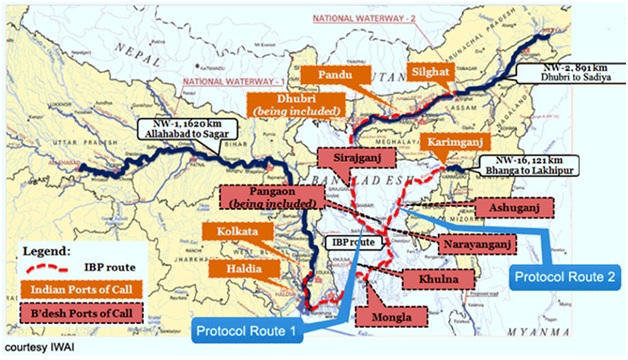
- There are five such waterways (or 10 routes, since the reciprocal route is regarded as separate).
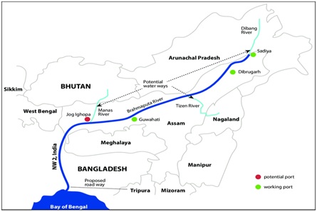
- In 2018, India and Bangladesh agreed to develop Jogighopa in Assam’s Brahmaputra Valley as a hub/trans-shipment terminal for movement of cargo to Assam, Arunachal Pradesh, Nagaland and
- In 2020, Dhaka and New Delhi began operations on the ninth and 10th protocol routes – the Daudkandi (Bangladesh) to Sonamura (Tripura) route along the Gumti River – with the first-ever export consignment of cement reaching Tripura from
River map of North-East
- The northeast is criss-crossed by multiple rivers. It has an estimated 1,800 km of river routes navigable for steamers and large country boats.
- Cargo moved by these routes includes tea, cement, coal, fly ash, limestone, petroleum, bitumen, and food grains.
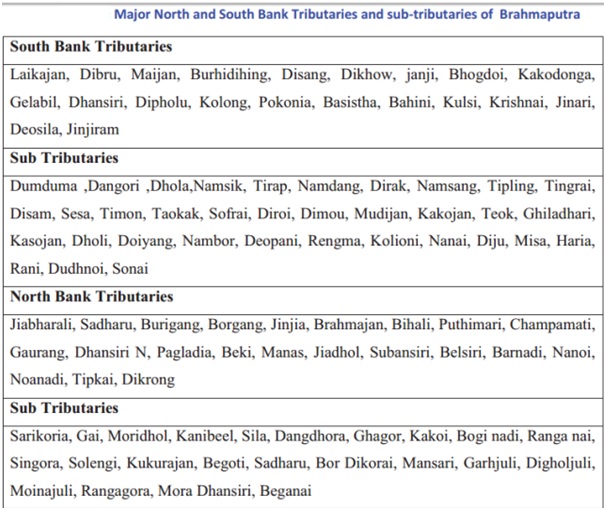
- Arunachal Pradesh: In Arunachal Pradesh, the rivers Lohit, Subansiri, Burhi Dihing, Noa Dihing, and Tirap are used for navigation by small country boats along those stretches where there are no rapids.
- Mizoram: The rivers Dhaleshwari, Sonai, Tuilianpui, and Chimtuipui in Mizoram are similarly used for navigation in convenient stretches.
- Manipur: In Manipur, the Manipur River, along with its three main tributaries, the Iril, the Imphal, and the Thoubal—are used for transporting small quantities of merchandise by country boats.
|
Brahmaputra Basin
|
How Bay of Bengal is emerging as the solution?
- The Bay of Bengal has become an arena of cooperation and competition amongst many.
- As India ventures to Act East, the Bay has emerged as a key region for its strategic manoeuvres.
- This maritime space is also geographically poised to be India’s ‘stepping stone’ into the wider waters of the Indo-Pacific.
- Important sea lanes of communication traverse the Bay of Bengal and its adjoining Andaman Sea before merging into the wider waters of the Indo-Pacific via the Strait of Malacca.
- The need to preserve the autonomy of these shipping routes in the face of concerns posed by a rising China, coupled with the lure of the Bay’s vast hydrocarbon reserves, has attracted stakeholders to its waters in recent years.
- The Bay has emerged as a zone of competition and collaboration between its littoral countries and the global powers involved in the region such as Japan, the US, and Australia.
If riverine connectivity is strengthened in the NER, enabling its ease of access to the Bay, such collaborations may prove beneficial for its development.
- Major ports which are particularly important are:
- Kolkata-Haldia in India: The Kolkata port under the Kolkata Port Trust is situated on the River Hooghly in West Bengal and is geographically India’s closest port to the Northeast.
- Chittagong in Bangladesh: The Chittagong port is the principal seaport of Bangladesh and ranks 76th amongst the 100 busiest ports of the world. It is situated on the Karnafuli River, 15-16 km from the sea.
- Sittwe in Myanmar: Geopolitically, Sittwe port, financed by India, stands as a counterbalance to the Kyaukpyu port in Myanmar, built by China and part of the BRI.
These ports, although riverine, have easy access to the sea, and if linked with the NER through multimodal connectivity will prove useful in enhancing the NER’s connectivity not only with Southeast Asia but also with the rest of India. It is thus worth assessing their potential.
|
Bay of Bengal
|
Conclusion
India’s northeast region faces myriad challenges in terms of geography, socio-economic conditions and political stability. And the solution lies in ‘enhanced connectivity’ by expanding the inland waterways and linking them across national borders using multimodal networks. The advantage of augmenting connectivity of the NER is two-fold: it will enhance the socio-economic conditions in the region and increase the foreign policy outreach to the east of the country
The revival and expansion of inland waterways promises to transform the region.