Climate Change Sees Swiss Alps Add Over 1,000 Lakes: Study
-
Context
Climate change has dramatically altered the Swiss Alp landscape -at a quicker pace than expected - as melting glaciers have created more than 1,000 new lakes across in the mountains, according to a study.
-
Background
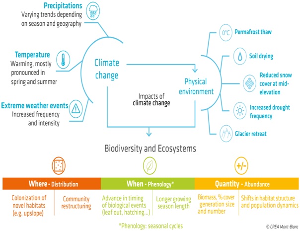
- Rapid changes in the climate have been recorded on a global scale since the beginning of the industrial era. These developments are characterized by:
- increases in temperatures
- changes in precipitation patterns
- an increase in the frequency and intensity of extreme climatic events (heat waves, droughts)
- At the scale of the European Alps, over the course of the 20th century, temperatures have risen by 2°C (3.6°F).
- This recent study showing addition of lakes is published by the Swiss Federal Institute of Aquatic Science and Technology or Eawag).
- Rapid changes in the climate have been recorded on a global scale since the beginning of the industrial era. These developments are characterized by:
-
Analysis
Key-highlights of Eawag Assessment
- Since the end of the Little Ice Age around 1850, almost 1,200 new lakes have formed in formerly glaciated regions of the Swiss Alps. Around 1,000 of them still exist today.
Little Ice Age
- The Little Ice Age was a period of regionally cold conditions between roughly AD 1300 and 1850.
- It was Earth’s most recent period of mountain-glacier expansion and retreat.
- Glaciers in the Swiss Alps are in steady decline, losing a full two percent of their volume last year alone.
- The Eawag assessment showed that there was an initial peak in glacial lake formation in the Swiss Alps between 1946 and 1973, when nearly eight new lakes appeared on average each year.
- After a brief decline, the lake formation rate surged between 2006 and 2016, with 18 new lakes appearing each year on average, while the water surface swelled by over 400 square metres (4,300 square feet) annually.
-
How did Alps evolve?
- The Alps emerged during the Alpine orogeny.
Alpine orogency is an event that began about 65 million years ago as the Mesozoic Era (about 250 million to 65 million years ago) was drawing to a close and the current Cenozoic that has formed the mountain ranges of the Alpide belt.
- At the end of the Paleozoic Era (about 250 million years ago), eroded Hercynian mountains, similar to the present Massif Centralin France and Bohemian Massif embracing parts of Germany, Austria, Poland, and the Czech Republic, stood where the Alps are now located.
- A large landmass, formed of crystalline rocks and known as Tyrrhenia, occupied what is today the western Mediterranean basin, whereas much of the rest of Europewas inundated by a vast sea.
- During the Mesozoic Tyrrhenia was slowly leveled by the forces of erosion.
- The eroded materials were carried southward by river action and deposited at the bottom of a vast ocean known as the Tethys Sea, where they were slowly transformed into horizontal layers of rock composed of limestone, clay, shale, and sandstone.
- About 44 million years ago, relentless and powerful pressures from the south first formed the Pyreneesand then the Alps, as the deep layers of rock that had settled into the Tethys Sea were folded around and against the crystalline bedrock and raised with the bedrock to heights approaching the present-day Himalayas.
-
Geography of Swiss Alps
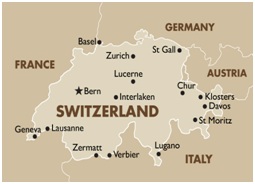
- The Alps are a mountain range across France, Germany, Switzerland, Liechtenstein, Italy, Austria and
- The mountainous alpine region of Switzerland is referred to as the Swiss Alps.
- The Swiss Alps are one of the three main geographic regions of Switzerland, the other two being the Swiss Plateau and the Jura Mountains.
- The portion of the Alps lying within Switzerland is sometimes referred to as the Central Alps, but more commonly known as the Swiss Alps.
- Countries: Switzerland shares the Alps with seven other countries: Austria, France, Germany, Italy, Liechtenstein, Monaco and Slovenia.
- Major mountain peaks: The Swiss Alps also have 48 mountain peaks which are over 4,000m.
- At 4,634m above sea level, the Dufourspitze, part of the Monte Rosa Massif, is the highest of Switzerland's peaks.
- The canton of Graubünden has more than 1,200 mountain peaks which are between 2,000 and 3,000m high.
- The canton of Uri has the highest density, boasting a 2,000–3,000m-high summit every 2.5km2.
Facts about Switzerland
- Switzerland is a small mountainous country located in the Western-Central Europe.
- The landlocked Switzerland is highly industrialized and has many advantages, thanks to its great geographical features.
- Five countries surround Switzerland: France to the west, Italy to the south, Austria and Liechtenstein on the east and Germany on the north.
- Switzerland is split into three geographical regions:
- Jura (10%)
- Plateau (30%)
- Alps (60%)

-
What if the world implements the Paris Agreement?
- Even if the world were to fully implement the 2015 Paris Agreement - which calls for capping global warming at at-least two degrees Celsius, two-thirds of the Alpine glaciers will likely be lost.
-
How do Alps respond to climate change?
- The consequences of changes are:
- significant glacier retreat
- reductions in the snowpack at mid- mountain elevations
- more frequent soil water shortages
- rises in the altitude at which permafrost is found
- Flood waves: The growing number of glacial lakes increases the risk of sudden outbursts and thus the danger of flood waves for the settlements located below them.

- The consequences of changes are:
-
What are the positive aspects of the glacial melt?
- Tourist attraction: The natural phenomena offer impressive attractions for tourism
- Opportunity for hydroelectric power: The artificial enlargement of the lakes opens up new opportunities for hydroelectric power.
-
Wrapping Up
The Alps are particularly vulnerable to climate change. Rapid change in climate is already affecting discharge of alpine rivers and is increasing natural hazards. Thus, immediate measures are required to conserve the ecosystem.

