China approves the plan to build a dam on the Brahmaputra in Tibet
China's Parliament adopted the 14th Five-Year Plan including the controversial hydropower project on the Brahmaputra River in Tibet close to the Arunachal Pradesh border over which India has raised concerns.
Context
- China's Parliament adopted the 14th Five-Year Plan including the controversial hydropower project on the Brahmaputra River in Tibet close to the Arunachal Pradesh border over which India has raised concerns.
About the proposed project
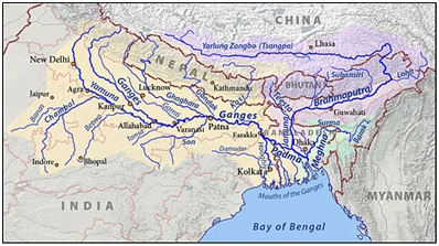
- China will build a major hydropower project on the YarlungZangbo River(the Tibetan name for the Brahmaputra) in Tibet.
- China is planning to build a "super hydropower station" in Medogcounty, where the YarlungZangbo Grand Canyon is located.
- Medog is the last county in Tibet which borders Arunachal Pradesh.
- The project could serve to maintain water resources and domestic security.

Concerns over the project
- India and Bangladesh both have raised concerns over the project.
- The lower riparian State with considerable established user rights to the waters of the trans-border riversis concerned about the availability of downstream water.
- The project isconcerned with the environment, national security, living standards, energy, and international cooperation.
Significance of project for China
- Source of renewable energy:The 60 million kWh hydropower exploitation downstream of the YarlungZangbo River could provide 300 billion kWh of clean, renewable, and zero-carbon electricity annually.
- Reduction in Carbon:The project will play a significant role in realizing China's goal of reaching a carbon emissions peak before 2030 and carbon neutrality in 2060.
YarlungZangbo River
|
Cooperation between India and China regarding water
- India and China established Expert Level Mechanism (ELM) in 2006 to discuss various issues related to trans-border rivers.
- Under existing bilateral Memorandums of Understanding, China provides hydrological information of Brahmaputra River and Sutlej River to India during the flood seasons.
- Under the arrangement, China provides flood season data of the Brahmaputra river between May 15 and October 15 every year.

